

 Azadi Ka Amrit Mahotsav
Cryosphere Sciences
Cryospheric studies on the earth surface include inventory, dynamics, changes, and interaction with hydrosphere, atmosphere etc. of snow, ice cover on land, sea ice and permafrost. Physical and chemical properties of these cryospheric elements makes them the most sensitive features to climate shifts and are thus centre of many scientific studies related to global climate change. These regions govern the global radiation budget , circulation of ocean currents, stability of sea level, amount of freshwater flowing into the rivers, morphology of landscapes etc For the last more than two and half decades Space Applications Centre (SAC) has been contributing to the development of methods/techniques for extraction and dissemination of reliable and quick information pertaining to polar and Himalayan cryosphere using data from Indian Remote Sensing Satellites. The present activities include:
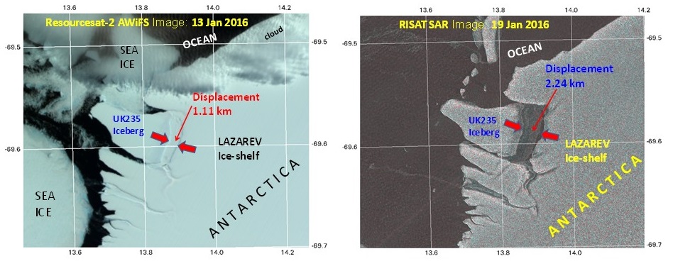
Drift of an Ice-berg in Antarctica observed using AWiFS and RISAT image of two dates.
Himalayan cryosphere studies
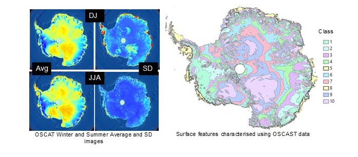
Surface morphology extracted for Antarctica using OSSCAT data by taking mean and standard Deviation images of summer and Winters in Antarctica. All classes differ in surface morphology of Antarctic Ice sheets.
Polar cryosphere studies
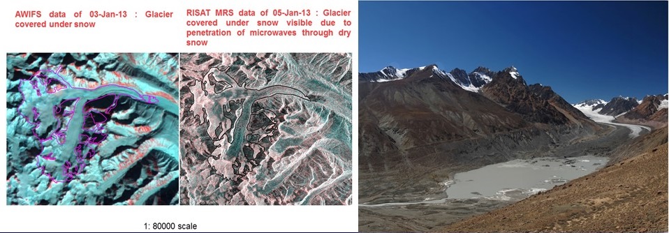
AWiFS and RISAT MRS images of closed dates showing a valley glacier (Samudra Tapu glacier in Himachal Pradesh) covered under snow but visible in RISAT image.
Drift of an Ice-berg in Antarctica observed using AWiFS and RISAT image of two dates.
Himalayan cryosphere studies
- Glacier facies mapping from C-बà¥à¤à¤¡ RISAT SAR, LISS III and DEM data
- Updating Glacier inventory of Indus, Ganga and Brahmaputra basins using LISS III/RISAT C-बà¥à¤à¤¡ SAR data
- Monitoring changes in area and snout of a large number of glaciers
- Glacier mass balance studies using Geodetic and empirical approaches
- Generating snow cover products of Indian Himalayan region at 5 days interval,
- Developed a Himalayan Glacier Information System to visualise the details of glacier information on a single platform
Surface morphology extracted for Antarctica using OSSCAT data by taking mean and standard Deviation images of summer and Winters in Antarctica. All classes differ in surface morphology of Antarctic Ice sheets.
Polar cryosphere studies
- Sea ice identification using Scaterrometer
- Sea ice thickness estimation using Altimeters
- Assessment of ice deformation around Antarctic margins optical and SAR data
- Velocity of ice sheet and polar glaciers optical and SAR data
- Morphological studies of Antarctic/Arctic region using optical and SAR data
- Sea ice occurrence and ice-berg studies optical and SAR data
- Scientific team from SAC participates regularly in expedition to Antarctica and remote glaciers in Himalayan region to validate information extracted from satellite images and to collect insitu data using instruments such as in-house developed Ground Penetrating Radar, Spectroradiometers, DGPS etc.
AWiFS and RISAT MRS images of closed dates showing a valley glacier (Samudra Tapu glacier in Himachal Pradesh) covered under snow but visible in RISAT image.
- About us
- Projects and Activities
- Work with SAC
- Business with SAC
- Resources
- Public Relations
- Students Corner
- Staff Corner

All Rights Reserved with Space Applications Centre.
This site belongs to Space Applications Centre, Indian Space Research Organisation, Department of Space, Government of India
Material featured on this site may be reproduced free of charge in any format or media without requiring specific permission except where specifically stated otherwise. This is subject to the material being reproduced accurately and not being used in a derogatory manner or in misleading context. Where the material is being published or issued to others, the source must be prominently acknowledged. However, the deemed permission to reproduce this material does not extend to any material on this site, which is explicitly identified as being copyright of a third party as well as to materials contained in the hyper linked sites. Authorization to reproduce such material must be obtained from the copyright holders concerned
Best Viewed with 1600x900 resolution or above | Supports Browsers IE 9.0 / Firefox 30.0 / Chrome 30.0 onwards