

 Azadi Ka Amrit Mahotsav
Hydrosphere
SAC carries out studies related to land hydrological modeling and applications. It involves retrieval of hydro-meteorological parameters from satellite and modeling of Hydrological Processes from field to National scale. Timely and reliable assessment of available water resources through satellites and models provide important input to devise strategies and water management in the country. Some of the studies of national importance are described below:
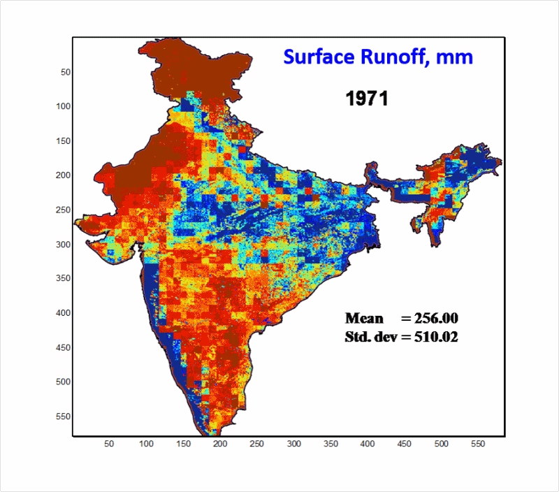

Surface Runoff modelling:A National scale surface runoff modeling was done using the modified curve number model. Rainfall, soil texture, land cover types, slope etc. were processed at grid cell size of 5x5 km. It was estimated that on average 33.8% of the rainfall got converted to the surface runoff considering the 35 years period (1971-2005). Changes in runoff provide valuable information for understanding the region's sensitivity to climatic variability.
Radar Altimetry for Inland water bodies:SAC utilises Saral-Altika satellite data regularly in near real time to monitor water levels in different rivers (Ganga, Godavari, Brahmaputra, Gandak, Kosi, Yamuna, Son, Ghaghara etc.) as well selected major reservoirs/Lakes (Ukai, Ranapratap, Bandhsagar, Gandhisagar, sambhar Lake etc.). Also, retrieved river water levels are being used for river flow modeling and other applications.
Flood and Hydrological Drought:Incessant rainfall in the hilly regions of North Gujarat and Rajasthan borders created flood situation during 25-29 July, 2015. Inundation simulations were done using the hybrid technique (coupling CN and 2D-overland flow models) and integrating remote sensing derived products such as rainfall, Land cover and DEM. Flood wave was detected in Brahmaputra river on 9 June 2015 using SARAL-Altika data. A detailed study on Ukai reservoir using SARAL-Altika data revealed lowest water levels in April 2016 as compared to previous years during same period.
Water Quality:Information contained in remote sensing imagery is used to accurately quantify water quality constituents. Water quality refers to water property in terms of physical, chemical and biological characteristics. Pollutants in water surface changes the spectral signature of surface water. Field campaign was carried out in Feb. 2016 to establish the spectral signature of water in Ganga river, near Buxar, Bihar under AVIRIS-NG Program. Water simulator model is being developed to simulate the reflectance spectra at different water quality conditions.
Effects of Depleting Ground Water:Over exploitation of ground water in Punjab and Haryana region has been reported by several studies using the satellite based gravity anomaly from GRACE mission and also using observed data. This decline in groundwater has enforced change in the irrigation practices which have been captured using the multi-year passive microwave (AMSR-E) soil wetness analysis. Study showed an overall 18-20 days delay (152 Julian day to 172 Julian day) in irrigation practices (in absence of rainfall) in the region during 2002 to 2011.
- About us
- Projects and Activities
- Work with SAC
- Business with SAC
- Resources
- Public Relations
- Students Corner
- Staff Corner

All Rights Reserved with Space Applications Centre.
This site belongs to Space Applications Centre, Indian Space Research Organisation, Department of Space, Government of India
Material featured on this site may be reproduced free of charge in any format or media without requiring specific permission except where specifically stated otherwise. This is subject to the material being reproduced accurately and not being used in a derogatory manner or in misleading context. Where the material is being published or issued to others, the source must be prominently acknowledged. However, the deemed permission to reproduce this material does not extend to any material on this site, which is explicitly identified as being copyright of a third party as well as to materials contained in the hyper linked sites. Authorization to reproduce such material must be obtained from the copyright holders concerned
Best Viewed with 1600x900 resolution or above | Supports Browsers IE 9.0 / Firefox 30.0 / Chrome 30.0 onwards