Human activities contribute to climate change by causing changes in Earth's atmosphere in the amounts of greenhouse gases, aerosols (small particles), and cloudiness. The concentration of atmospheric CO2 has increased from a pre-industrial value of about 280 ppm to 400 ppm in 2015. The CH4 abundance in 2005 of about 1774 ppb is more than double its pre-industrial value. The fourth assessment report of International Panel for Climate Change (IPCC, 2007), predicts the surface air warming: 1.8°C to 4.0°C (under different scenarios), Sea Level Rise of 0.18 ' 0.59 m, high frequency in heat waves and heavy precipitation events.
Climate change forms one of the most important global environmental challenges, with implications for food production, water supply, health, energy, etc. It is essential to study the impacts of climate change and thereby suggest mitigation measures. Goal of space based global change observation, together with other observations and studies, is to provide a sound scientific basis for developing national and international policy relating to natural and human induced changes in the Earth system.
Space based remote sensing data helps in mapping earth resources, monitoring their changes and deriving bio-geophysical parameters. All this information helps in identifying the indicators and agents of climate change. The space-based inputs can also be integrated with physical simulation models to predict the impact of climate change. It provides information related to three aspects (i) the indicators of climate change (ii) assessment of agents of climate change, their sources and distribution pattern and (iii) modeling the impact of climate change in various fields and natural resources that would be of help in planning towards adaptation measures and preparedness.
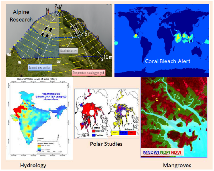
 Alpine ecosystem dynamics
 Coral bleaching
 Mangrove characterization
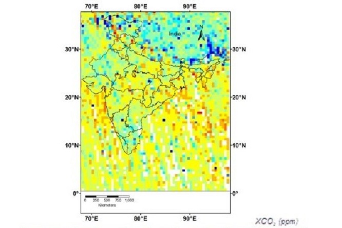 Trace gas variabidlities
The programme on Climate change Research In Terrestrial environment (PRACRITI) -Phase programme presently consists of climate change/ climate based modelling and characterization studies of diverse habitats ranging from vital/ critical habitats like Indian coral reefs and mangrove swamps to high altitude Himalayan alpine ecosystems, Indian eco-hydrology and investigations on Indian monsoon teleconnection with the polar environment processes. The studies are carried out with synergistic use of ground measurements, space inputs and climate projection data. The detailed objectives of different projects are
- Modeling Eco-hydrology of India and Impact of Climate Change
This study emphasizes on development of cell based integrated hydrological system model for National water balance. Water balance analysis and impact of climate change over major and medium rivers basins of India, snow melt from Indian Himalayan, hilly regions etc.
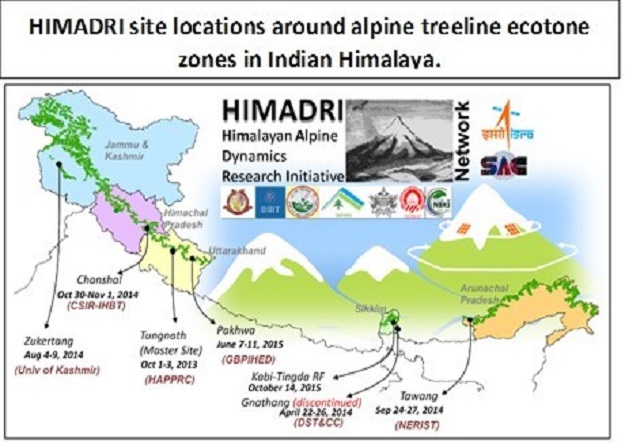
- Alpine ecosystem dynamics and impact of climate change in Indian Himalaya
This study is about experiment and modeling for the establishment of long term ecological records in alpine ecosystems of Indian Himalaya. Other objective includes development of seamless geospatial database, climate change impact on alpine landscape, understanding alpine eco-system response etc.
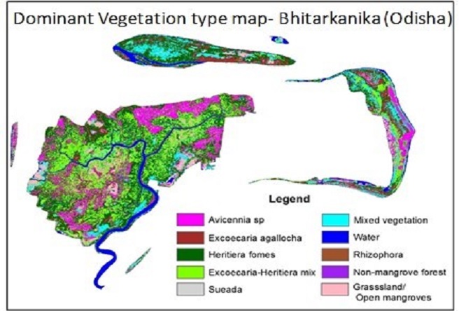
- Bio-physical Characterization and Site Suitability Analysis for Indian Mangroves
Major goal of this study is to characterize mangrove ecosystems of India using remote sensing data. Modelling of biophysical parameters, Estimation of gross primary productivity, Identification of mangrove afforestation/plantation conducive areas etc. will also be studied.
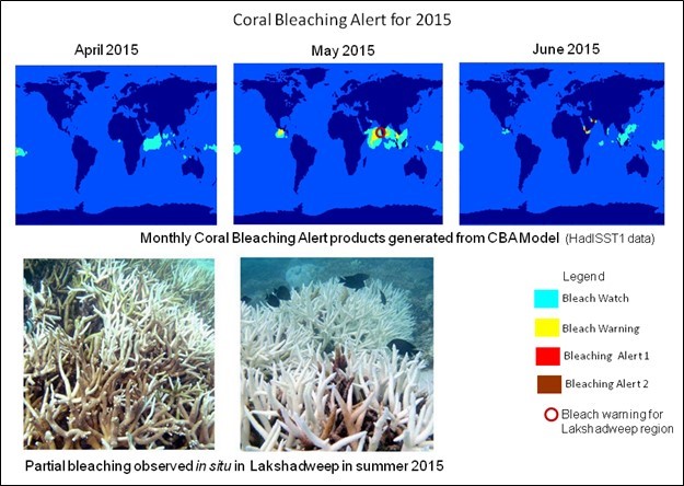
- Impact of Global Changes on Marine Ecosystems with special emphasis on Coral Reefs
This study highlights on developing region specific coral bleaching systems for five major Indian Reef regions of India. Study aims for Micro-habitat zonation of reefs, approach for reef substrate signatures, impact of climate change on coral reef ecosystem etc.
- Investigations of Indian monsoon teleconnection with the polar environment processes
The major objective of this study is to develop models for understanding of teleconnection between the polar environment and Indian monsoon using satellite derived data and indices.
 Evapotranspiration for agricultural drought characterization
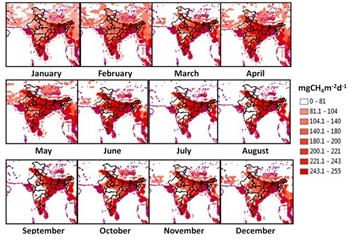 Coupling of surface emitted methane and heat fluxes in agriculture
Progress and Future Plans The studies have established sites for long term changes in Indian alpine region and database of the alpine treeline in GIS ready format, SST based region specific coral bleaching alert system, photosynthesis estimation of selected mangrove forests and satellite based hydrological model for national scale water balance modeling including Himalayan region and water balance analysis over various systems of India and understanding of tele-connection between the polar environment changes and the changes observed in Indian monsoon.